Thursday, June 20, 2013

Mount Rainier via Liberty Ridge Part 2

Before turning in at Thumb Rock we checked the weather and conditions for the summit tomorrow. The forecast was predicting partly cloudy, mild temps, and winds of 65+ mph. This wind was a little concerning. However, the thought of having to downclimb the section below thumb rock was terrifying. We were committed by this point. We had to go up. I didn't really sleep that night, never could calm my brain down. I could however hear the wind steadily picking up as the night went on.

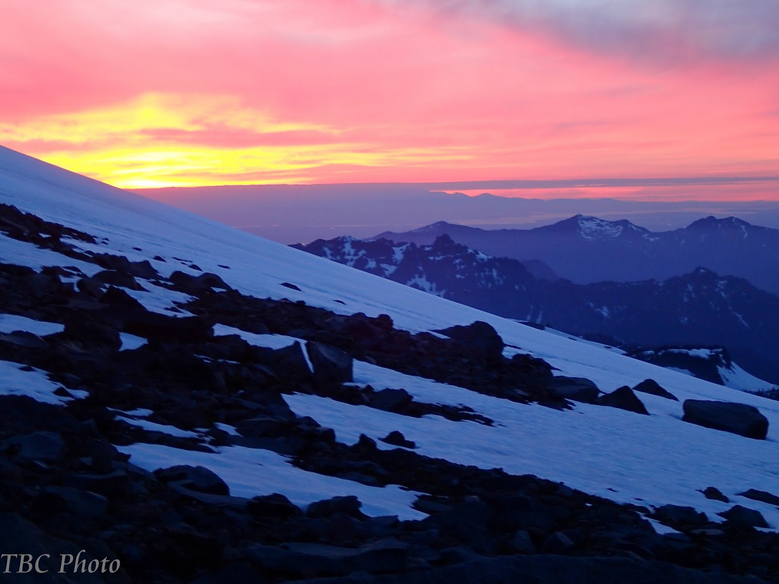
We got an alpine start the next morning and were ready to go just before 2am. The wind was definitely stronger but still tolerable. Geared up and feeling our way with headlamps I took the lead. I knew I would need Jon to lead and pitch out the ice ahead of us, so I tried to lead until that point to save his energy. We went to the right above thumb rock working away back on top of the ridge line across snow and horrible rock sections. We were still technically on the upper Carbon Glacier here and at one point I punched through up to my waist into a crevasse or giant snow cave. Having your legs dangling free as you spread your weight and crawl out of a hole in the snow absolutely wakes you up, even at 4am. Despite the deep snow, darkness, and increasing wind we were making good time. I led our way across the ridge line and onto the edge of the Willis Wall just as it started to get light.


With the light we could finally get an idea of what exactly the mountain was throwing at us. We were totally clouded in and the wind was steadily increasing. The clouds made navigation tricky since we could no longer see the landmarks we were using to guide us. Also, since the air temps were still relatively warm the moisture from the clouds was condensing and misting on us. It was like climbing in the rain, with every gust of wind freezing the moisture.

"Jon, I think we need to go up" 

I reached the ice face next to the black pyramid and passed the lead off to Jon to pitch out the climbs from here while I belayed and followed.


To this point we had been making really good time, but the moisture continued to come down and the wind continued to increase. It was now strong enough to force us to stay low and brace. An interesting concept as I stand in crampons on a tiny chopped out ice foot hold. Jon led and pitched out the first pitches of ice beautifully. But we were both starting to feel the conditions. Our gore-tex were entirely soaked through, my "water proof" gloves would drip water when I squeezed my ice tools and we were getting noticeable chilled from the wind. Before the last pitch of ice to the top of the black pyramid I looked at Jon and finally had to say what we were both thinking, we had to get shelter and get our core temps up. We were both shaking and totally soaked through, going on like that was just too dangerous.

Jon agreed so we finished the last pitch of ice and were just above the black pyramid and below Liberty Glacier. We found a spot of sheltered snow and dug in preparing a platform big enough for our tent. We braced the tent out as much as we could then dashed for the sleeping bags and out of the wet clothes. We passed out there as the winds absolutely battered the tent for at least 4 hours.

When I finally woke up the clouds had at least lifted and the sun was shining but the wind was still blasting the tent, enough that we were concerned it would fail. We discussed our options and realized they both were bad. We could stay the night at this bivy site, but it was extremely exposed and we weren't totally confident the tent would hold. We also were not confident we could melt snow for drinking water with the conditions and exposure as they were. The other option was push for the summit and try to find something more sheltered on the opposite side of Liberty Cap. Going for it meant putting back on the frozen wet clothes (didn't dry at all) and risking hypothermia and frost bite. We decided we had to go for it, the sun was out we could see and hopefully our body temps would dry our wet and frozen clothes.

Above the Black Pyramid we encountered the technical crux of the climb, at least three more pitches of steep (approximately 75+ degree), hard ice. Just as before Jon pitched it out while I belayed and followed. By this point we were both getting exhausted as we climbed and fought the wind. We later learned that wind speeds that afternoon and the next day were pushing over 80mph.


We cleared the ice then made the last push on to Liberty Glacier up to Liberty Cap, 14,112 ft.


We sat at the summit for around 45 seconds before descending between Liberty Cap and the true summit to find a sheltered bivy site. We knew the risk of taking this extra bivy since we only had limited amount of fuel to make water, but the sun was setting, we were exhausted, and just needed the rest. When I took my boots off to crawl in the tent, my socks had frozen to the inside of my boot and I couldn't dislodge them. Both of our finger tips were numb and I couldn't feel my big toes.


We slept in some the next morning to make sure we were good and rested. What finally pushed us out of the tent was the shifting winds. We were no longer sheltered and the tent was once again taking the brunt of 70-80 mph winds and threatening to collapse. We burned the rest of our fuel melting water to get us down, then quickly packed everything up and headed to the east to try and find our way onto the Emmons Glacier.  My socks were still frozen to my boot and my finger tips and toes were still numb, but at least they were still the proper color!


Once we got to the ice wall above the glacier, we were clouded in again and could no longer find our land marks.


We climbed up to Columbia Crest 14,400ft on the true summit to get a better vantage point. We had to be precise in where we dropped off the summit in order to avoid the ice wall, and make sure we didn't end up 20 miles off course at the bottom. After waiting several minutes for momentary cloud clearings, we finally had our points of reference lined up and started our descent.

By now we were ready to get down. Naturally after dropping just a couple hundred feet off the summit the clouds cleared and visibility was perfect. The lower we got the more sheltered from the wind we were. We found the well used trail on the Emmons Glacier and plunged stepped our way to Camp Schurman. The Emmons Glacier was well traveled but the warm temperatures and being sheltered from the wind was making the snow unstable and both Jon and myself punched through hidden crevasses multiple times. We reached Camp Schurman and checked in with the ranger to let them know we were overdue a day but fine. They said no one had summitted any of the routes in two days due to the winds. After some high fives and strutting, we continued descending over the Inter Glacier, glissaded Glacier Basin and made it back to the car before dark. We sped to town and found a Mexican restaurant that was open late and literally ordered the largest things on the menu.

This was a true adventure that pushed my comfort zone. We were totally reliant on each other and our abilities to finish it, and it is only now setting in exactly what we accomplished. That being said, I hope the feeling returns to my finger tips and big toes soon.


Mount Rainier via Liberty Ridge Part 1

The whole idea of this trip started back in February when myself and three others tossed around the idea of climbing Mount Rainier from the Muir Cabin and the extremely popular Disappointment Cleaver route. It's a wide open trail, very popular, often wanded and mostly a difficult hike through snow and over glacier. For lots of reasons that plan fell through. However, I still had an itch to do some true alpine climbing so I tossed the idea of Rainier to my friend Jon, who has successfully climbed Rainier once via the more difficult Kautz Ice Chute, and attempted a second time on still more difficult Liberty Ridge. He had been forced to back off of the approach for Liberty Ridge in 2012 due to unstable snow conditions and high avalanche risk. When I passed the trip idea to him, he was adamant about attempting Liberty Ridge again.

Liberty Ridge is a Grade IV-V alpine climb. It's long; the starting elevation is less then 5,000 feet and you have a full day and a half of approach before you ever even start climbing the ridge itself. It's exposed; 5,000+ feet run out means falling simply isn't an option. It's technical; in addition to crossing 5 glaciers before all is said and done, there are several pitches of front point technical ice climbing. It's committing; once on the ridge it is way more dangerous to go down. We would have to carry all of our gear over the summit and down a different route, instead of taking a light summit pack and coming back to a camp. It's also a classic of North American alpine climbs. I knew this would be a difficult and intimidating trip for me. I told Jon I'm in if he thought it was technically within my abilities, the rest would just be mental.

The trip was booked.

Flying in I got my first views of the mountain and the actual route we would climb, I think my response was something like "Holy Crap!"
 
(Liberty Ridge is the ridge line right-center facing directly towards you)
 
Upon arrival in Washington we got caught up with the current mountain conditions. Our original plan was to go super light and fast, and try to be off the mountain in two days to limit our chances of being caught in rotten weather. Reports from the ridge were describing deep heavy snow, there was also a large group a day ahead of us that we would have to meet at Thumb Rock. With those conditions in mind we decided to stretch it to a traditional three day climb.

We found a nice campsite just outside the park and got a good nights sleep before the packing began. We had gear for two or three contingency climbs also in case the conditions or weather wasn't favorable. Organizing gear took some time.


It was a nice camp site though.


First stop was the Ranger Station to give them our itinerary and pick up our blue bags (pack out your waist).

We arrived at the trailhead parking lot and did some last minute packing. Packed weight at this point, carrying nearly everything, was around 40 lbs. Fortunately I knew this was the heaviest it would be since I would be wearing almost everything in my pack for summit day.

Jon looks ready
 
I think I look ready

The first several miles were just gentle incline trails as we headed towards Glacier Basin. We would catch occasional glimpses of what was to come.
 
Rainier is the clouded over peak on the right
 Boot adjustment

After about four miles of hiking on trail and eventually snow, we arrived at Glacier Basin.


Our next target was St. Elmo's pass straight up the middle of the basin.


From here up the snow was deep, wet, and heavy. Progress slowed down to a sludge and pushing through knee deep snow in places was exhausting. Proper pacing was definitely important.

The climb to St. Elmo's Pass
 
Leaving the trees behind 

 
 After skirting under the Inter Glacier, we gained St. Elmo's Pass and stopped for lunch while we negotiated the best route forward. We would be dropping onto the Winthrop Glacier and traversing across to Curtis Ridge to bivy for the evening. The large party that was a full day ahead of us left some decent tracks across the Winthrop that would help in negotiating the snow covered crevasses.
 
 
Winthrop Glacier from St. Elmo's Pass with Curtis Ridge in the distance.


Looking back down Glacier Basin

 
 After roping up, we plunged our way down onto the Winthrop and started the cautious traverse.


The Winthrop Glacier was in good shape. Most of the snow bridges were still strong and we had little trouble navigating the crevasses.


After sludging across the Winthrop we finally gained Curtis Ridge and skirted around to the far west side to find a bivy site for the night.


From our bivy site on Curtis Ridge we could finally get a good view of both the Carbon Glacier and Liberty Ridge. The deep snow would actually be to our benefit on the Carbon. It's a super active and  highly crevassed gnarly glacier that runs 900 feet deep in places. It can take the better part of a day just navigating the crevasses safely. Fortunately the lower sections looked well snowed over and we still had tracks in places to guide us through the upper Carbon. Avoiding the hidden crevasses would be the name of the game. Scouting the upper sections of Liberty Ridge we were able to see several hundred feet of ice up near the black pyramid at around 13,000 feet.


Even from this vantage point we could hear and see the dynamic nature of the mountain. The Carbon Glacier was continually creaking and cracking as it shifted or big seracs would cave off. Both the Willis Wall and Liberty Wall would throw rock or small avalanches off of it regularly. It was impressive, humbling, and intimidating at the same time.
 
Liberty Ridge is the line right up the middle with the Carbon Glacier below and Liberty Cap/Liberty Glacier at the top. To the left and right of the ridge are the extremely active Willis an Liberty Walls respectively. With as much avalanche and rock fall activity it's insane to think people have actually climbed those walls. The ridge line is about the most protected place you can be. You can also see the reflection off the ice face just to the left of diamond rock formation in the center (black pyramid) below the Liberty Glacier.

 
We had quite the impressive sunset that night.
 
The next morning we were still holding good with perfect weather. If anything it was going to be a little warm! We could see the party that was at Thumb Rock last night working their way across the ice face up by the black pyramid. They had absolutely perfect summit weather.
 
 
We packed up then found our way down the crumbly, crappy, volcanic ash and rock to access the Carbon Glacier and rope up.


The Carbon was just awesome. Ice fall, and gaping deep crevasses. We managed our way through most of it. We both punched through a couple times but were able to catch ourselves and work around the weak snow bridges.


The upper sections of the Carbon Glacier are really when the approach ended and the climbing began. We started navigating the glacier while climbing steep snow.
 
I think it was right around this point when a serac the size of an apartment building fell off Liberty Wall and crashed down onto the Carbon. I couldn't react or even think fast enough to get a camera out. It just makes you feel so tiny. We just stood there in awe and tried not to pee ourselves.


 This one was DEEP!

 
We finally reached the base of Liberty Ridge and started our climb. We were working around more cruddy rock in places. A solid hold or foot placement was non-existent on this stuff.
 
You can see our second bivy site, Thumb Rock, sticking out above the ridgline. Still several hundred feet above us. 

Looking back on the Carbon


Last push to Thumb Rock. We are starting to get that exposure!

We reached Thumb Rock around 2pm, just over 10,000 feet. Plenty of time for us to melt water for tomorrow, get some food, hydrate and prepare for the push for the summit. We lounged and watched the rocks and avalanches come off Liberty and Willis Wall before hitting the sleeping bags around 7pm. The mountain would make noise through the night, some sounds closer then others.